For a very long period of time, infrastructure inspection has been done through labour-intensive techniques such as scaffolding, rope access, aerial lifts, and manual surveys. Such traditional methods expose workers to risk and require a lot of time and effort to use. While conducting infrastructure inspection with the use of drones, one has the chance to fill this gap by making the procedure faster, safer, and more precise. The global market for drone inspection is currently valued at more than $18 billion and is expected to grow at a double-digit pace over the next decade.
In India, developers and contractors have begun to incorporate drones into their regular infrastructure inspection, such as in power lines, bridges, highways, and pipelines. With some potential, there are several challenges that remain unsolved, including battery endurance limits, regulatory permissions on beyond-visual-line-of-sight (BVLOS) flights, GPS-denied environments, and integration with existing maintenance systems. Through this blog, we try to explore the core capabilities of drones for reshaping infrastructure inspection, choosing the right drone services to address prevailing challenges in the industry and presenting measurable outcomes while evaluating the future prospects.
Core capabilities that drive the drones in infrastructure inspection
Data-processing using Real-Time Analytics with AI:
Modern drones with various modular payloads for infrastructure inspection, including sensing modes, electro-optical (EO) cameras, infrared (IR) sensors, and LiDAR scanners. This range of characteristics of the drones aids operators in identifying the:
1. Structural flaws such as cracks, spalling, or corrosion in the assets.
2. Thermal irregularities which suggest leaks, insulation problems, and delamination.
3. Geometric distortions and structure misalignments.
4. Surface degradation that tends to be invisible from ground zero.
In this way, by following identical flight routes and standardised imaging procedures, drones can collect data from the same position and orientation during every inspection. This allows teams to be consistent in comparing results over time, helps to identify early signs of degradation, and schedule maintenance before small issues escalate, ultimately ensuring asset longevity.Extended endurance and payload capability:
Based on industrial requirements, heavy-lift long-endurance UAVs are now essential for mega infrastructure projects as they can carry multiple payloads such as equipment, tools, lightweight systems, and construction materials wherever it required. Other than this, infrastructure inspection drones can remain in flight for extended periods, sweeping large project sites without repeated battery changes.
This coordination of payload and staying endurance capability not only enhances operational performance but also reduces manpower, mission downtime, and total project cost, rendering one of the core capabilities of drones in infrastructure inspection.High-precision navigation and stability control:
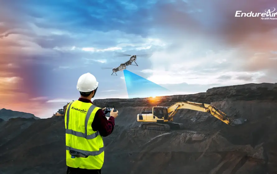
Sometimes, drones are required to fly close to pylons, bridges, towers, and factories, where stability and accuracy are of utmost importance. By using Real-time kinematic positioning (RTK) GPS technology, visual-inertial odometry (VIO), and high-end flight controllers provide centimetre-level positioning precision is provided, even in places where GPS are inaccessible, which prevents the risk of collision.
Digital twin to simulate real-world scenarios:
Data that is captured from drones is used to seamlessly integrate into digital twin environments to generate dynamic, real-time 3D copies of the physical assets. These virtual copies of the prints allow operators to simulate real-world scenarios, detect structural fatigue, and determine possible failure points well ahead of when they would otherwise occur.
To make the digital twin of any asset possible, the system depends on:
1. Machine learning models for scanning repeat defect patterns to predict when and where upcoming issues will arise.
2. AR and VR interfaces for helping engineers and planners inspect assets virtually before actual action.
3. Cross-system integration of drone data correlating with SCADA, or ERP systems for offering a comprehensive operational view of infrastructure health.
How are drones used in infrastructure inspection
Especially for owners and contractors deploying assets across different locations, operating drone fleets, managing pilots, and processing infrastructure projects can be complex. To mitigate these existing challenges, drone-as-a-service (DaaS) can be seen as a reliable solution. The solution typically encompasses end-to-end drone operations, including mission planning, regulatory compliance, trained pilot deployment, real-time data collection, and post-flight analytics. DaaS providers oversee the complete inspection life cycle, from aerial flights through to AI-based defect recognition and digital twin production, without the client having to get their hands dirty.
This model allows organisations to obtain on-demand drone inspection data from multiple locations, all aggregated onto a single cloud-based platform for greater visibility, reporting, and decision-making. This eliminates the necessity of buying and maintaining their own drone fleets, and it also mitigates initial capital expense as well as operating expenses, so organisations can allocate it for other key purposes.
The process of using a drone for infrastructure inspection involves the following key steps:
Step 01:
It first starts by choosing the drone according to the client’s requirements. VTOL drones are ideally suited for linear surveys along long distances without the need for runways, while multirotor drones are best for high-altitude or confined areas.
Step 02:
Secondly, installation of modular payloads is critical as inspection work could demand sensors like EO, IR, multispectral, or LiDAR based on the application.
Step 03:
Thirdly, Operational factors like endurance, wind tolerance, Global Navigation Satellite Systems (GNSS) accuracy, sensor redundancy, and data transmission range must be assessed before going for an inspection.
Step 04:
At last, compliance with DGCA regulations, certified pilots, secure data-management practices, and integration with existing asset-management systems should be reviewed carefully before using the drone for inspection.
Uses of drones in infrastructure inspection by industries
After all, choosing the right drones with necessary modular payloads is only half the equation; the true value emerges when these systems are deployed across industries where precision, reach, and data-driven insights redefine maintenance and safety operations. Such industries include:
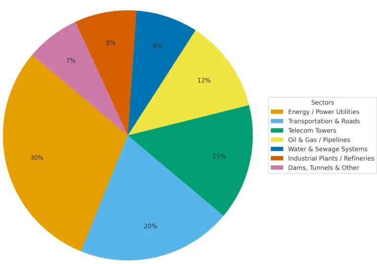
Energy / Power Utilities (30%):
Drones are used for patrolling transmission lines, substations, and insulators at scale, spotting hotspots, corrosion, and vegetation risks.
Transportation & Roads (20%):
High-speed bridging surveys of flyovers, embankments, and corridors allow for crack detection and as-built verification with minimal traffic disruption.
Telecom Towers (15%):
High-resolution EO/IR imaging in close proximity records antenna alignment, rust, and mount integrity. Thus, it provides automatic reports, reduces climb time and enhances crew safety.
Oil & Gas / Pipelines (12%):
Aerial LiDAR/thermal scans pick up leaks, encroachments, and ground movement on long pipelines.
Water & Sewage Systems (8%):
Canals, spillways, and treatment plant inspections with drones reveal seepage, slab leakage, and clogs.
Industrial Plants / Refineries (8%):
Drones inspect hard-to-reach locations such as stacks, flare tips, and conveyors without interrupting production
Tunnels & Other (7%):
High-resolution mapping & photogrammetry track concrete condition, rockfalls, & deformation in inaccessible assets.
How Drone Intelligence is driving the future of infrastructure inspection
Stepping into the next decade, infrastructure inspection using drones is going to be transformed at a deep level by drone intelligence. These platforms will not just scan but learn, adapt, and respond, having a seamless connection with digital twins and operation control systems.
- With the capabilities of autonomous operations, future drones will conduct end-to-end inspection flights automatically from take-off to data acquisition. Accordingly, it helps reduce dependency on human pilots.
- Using swarm capability multiple drones can collaborate to inspect lengthy or complex structures simultaneously, allowing them to increase speed and coverage.
- By adopting real-time analytics integrated with AI detection, drones can process images to detect cracks, corrosion, or thermal defects, enabling real-time decision-making.
- Drone-in-a-Box Systems, a feature of drones for auto-deployment, its charging, and docking stations will facilitate round-the-clock inspections without manual setup.
In future, the use of drones in infrastructure inspection is a paradigm shift from reactive inspection to a proactive, intelligence-driven mechanism. What previously took weeks now occurs quickly and safely. Drones such as SABAL from EndureAir Systems exemplify this transformation. With its heavy-lift capability, variable-pitch rotors, and long endurance, SABAL can carry LiDAR scanners, thermal sensors, and high-definition cameras to capture detailed insights across powerlines, bridges, refineries, and transmission corridors. This enables precise fault detection, terrain mapping, and predictive maintenance even in high-altitude or hazardous environments where human access is limited. This is how organisations will achieve fewer outages, improved turnarounds, safety compliance, and a clearer route to sustainable, lifecycle-optimised infrastructure inspection.